
Scofflaws? Miles Walked: 85.6
Dylife to Machynlleth
When I woke up today the Apple Health App on my phone said I had a new trend. It said the last five days had a higher daily step count from my normal average of 10,061 to 32,982. It’s always nice when technology acknowledges that you are on a hiking vacation. I think I feel every one of those steps, too!
Bernie and Karen from the wonderful School House B&B took us back to the starting point for today’s adventure. The weather forecast said it was only a 30% chance of rain all morning, but it was already 100% drizzling when we got back on the trail. We also loved that the wind was blowing the rain directly into our faces. So far, the weather is holding to the pattern of a day of sunshine followed by a day of rain. It’s also working out that the rain only occurs when the day is going to have a lot of big views of the other mountain ranges in Wales, like Snowdonia, and Brecon Beacons. I wonder who we managed to upset at the Welsh Weather Control Board that is filing the paperwork to give us such great “luck”?
Right after we got to the ridge, we passed the remains of an ancient tiny Roman fort-let, who’s size was about the footprint of our house. Given the wind and rain we were experiencing, any of those poor Roman Legionnaires that were stationed up there must pissed off their commanders.
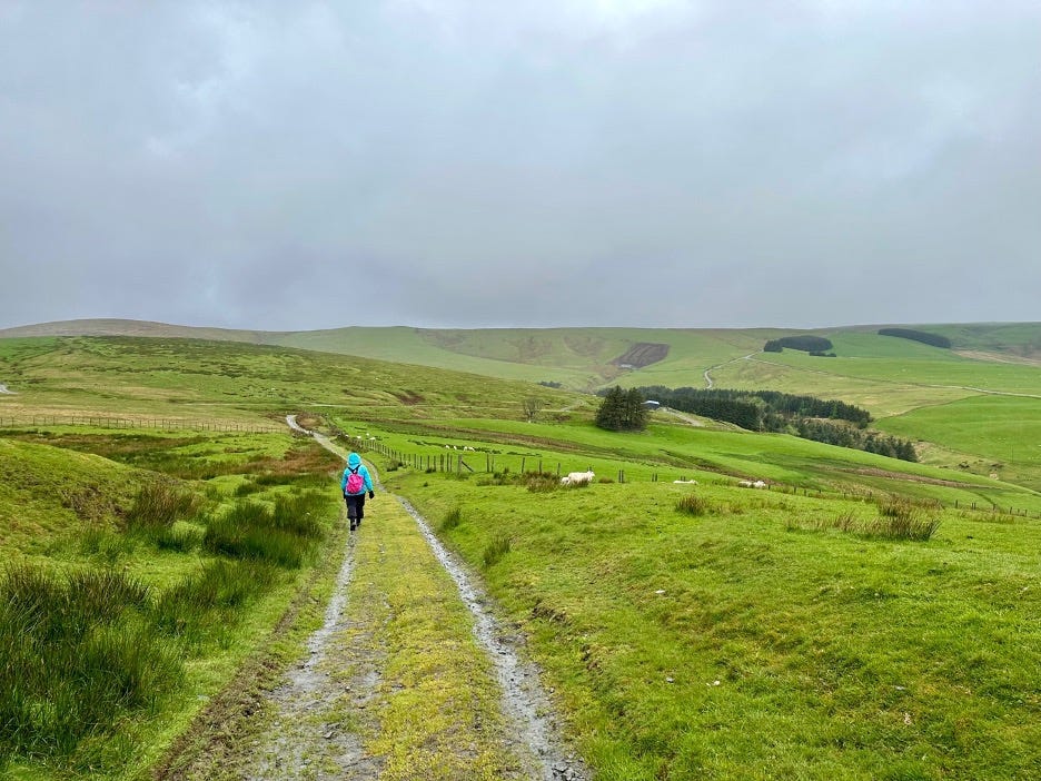
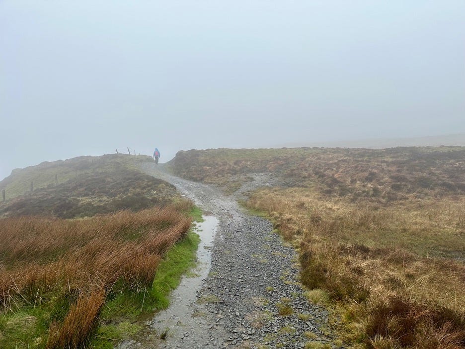
We were still passing by sheep fields, but the main part of the early walk today was to get into the wild moors above Dylife so we could see what the area looked like before man remade the environment. Just to spite us the rain got harder, and the clouds got lower so we could experience the moors at their worst. While I appreciate being all hardcore, we had to think that the weather was just mocking us.
We were paralleling the deepest ravine we’d seen to date and it’s an interesting geological formation. We’ve been crossing numerous streams all through the hike, but I guess the geologic time for most of them has softened the depth they produced in the hills. The deep valley produced by the Clywedog River in these parts is entirely different than all the others. On the ridge, we saw more of the typical Welsh shale that we had seen in other places. Even when we crossed the upper deep ravine, the stone didn’t look different than other places to my untrained eye. I’ll have to ask my Uncle Pete and cousin Mark, an earth scientist and geologist, about how one stream can produce such a different valley than any other stream in the area.
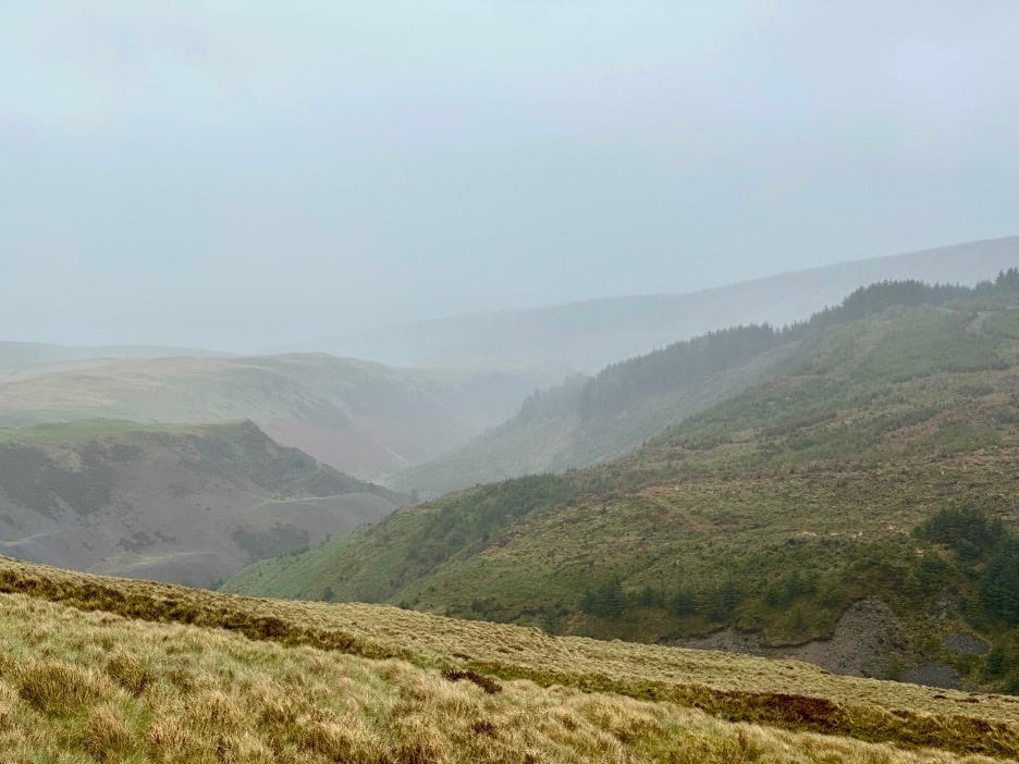
We were able to see a couple of the waterfalls mentioned in the guidebook but because of the clouds and rain, not all of them. Interestingly, the water in the streams has a reddish tint when pooled and has a higher acidity than normal. It must have something to do with the minerals in the land.
When I was talking with Bernie last night about the area, especially around Dylife, he said mining was the only activity in the old days. The soil is quite thin here. In some abandoned quarries we passed at lower levels, the edge of the quarry has maybe three inches of soil. Up on the moor area the soil level was maybe half an inch at best. When I asked Bernie why the Welsh were such good miners, he said “When it’s the only thing you can do to survive, that’s what you do.” The entire area we are walking in right now is riddled with mines. On the moors, we came across a long abandoned mine from probably the 1850s. In the picture below Pam is standing in front of what I think is the mechanical building that contained the machinery that lifted rock and ore from the mineshaft, which is that big hole directly to her right.
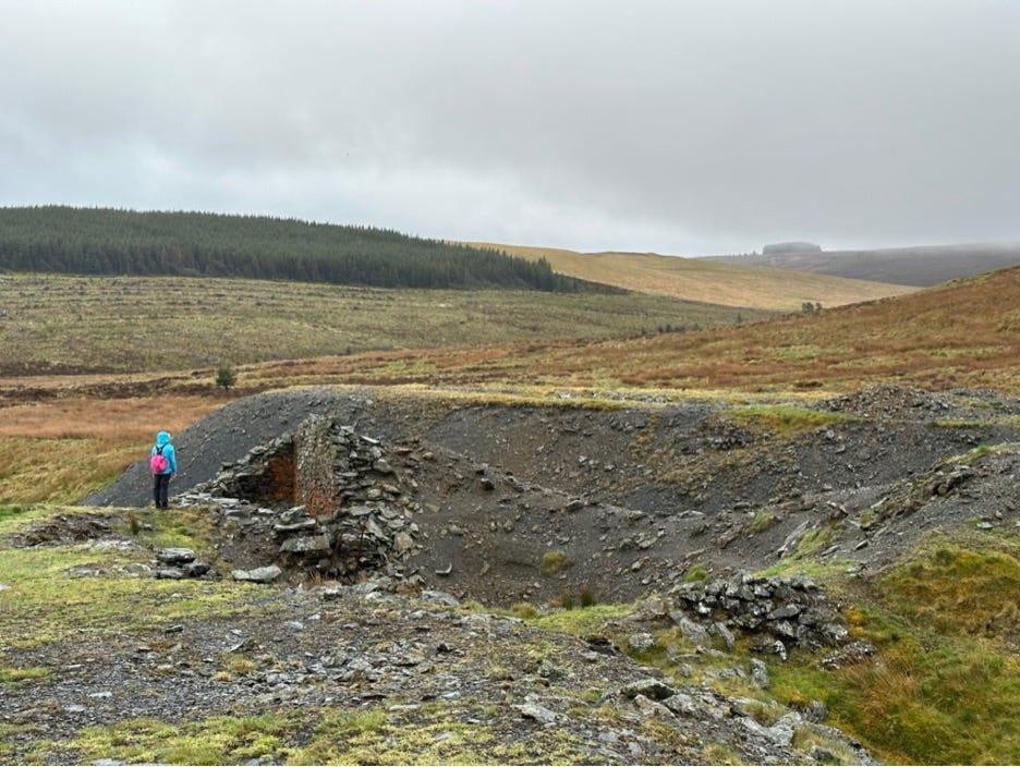
All we could think about was how hard the work was in those days. We were a solid hour walk from the Dylife area and most of the towns were another hour or two walk from there. People really did whatever it took to survive back in those day. At the bottom of the mine shaft, which has collapsed, was a sheep skeleton. This land is so hard, we didn’t see any sheep. I wanted to get the skull, but Pam didn’t want me to become yet another mine casualty.
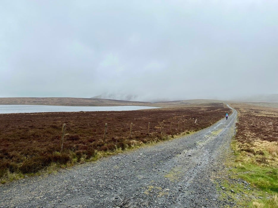
A half an hour past the mine we saw our first natural body of water on the trip, Glaslyn Lake, which forms the heart of the Glaslyn Nature Reserve. (That’s why this area is undeveloped.) This high alpine lake has a very high acidic concentration and very little lives in it. From where I took the picture below there’s a big, beautiful mountain behind it. I guess you’ll have to just trust me on that one as you can see how low the clouds were. In fact, this was the one point where we had the longest views on the moors for all of 15 minutes.
After walking 20 minutes past the lake, we passed another deep ravine made by the Nant Fadian River, but we were completely cloud bound so never even saw it.
We started a long down and finally broke free of the clouds and got our first proper view of the day.
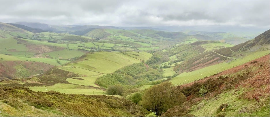
Continuing down for another 45 minutes we were mostly soaked from the morning activities as it was still raining. We did have a very sad experience. In front of one of the gates on the trail, a sheep was directly in front of the lever we needed to open. When you get within 15 feet or so of a sheep, they run away but this one stayed put until we were about six feet away. I thought it was just scared but saw that something was wrong with this sheep. It very slowly moved, and it was obviously in pain but never made a sound. She moved about three feet away so we could access the gate level. She turned away from us and she had rectal prolapse that had completely dried. We felt terrible for that poor girl.
We’d been dealing with the rain and wind for over half the walk and, honestly, it was getting old. As I was looking at the map on my phone, we got a little data signal and saw that the 30% chance of rain had jumped to 60%, which meant 200% on the ground. We looked at each other and had to admit that today was losing it’s fun. This was especially apparent in that we were at the bottom of a valley, and I calculated that we were at looking contour lines showing at a 200m (656 ft) up, 120m (394 ft) down, followed by a 150m (492 ft) up and I stopped calculating at that point.
Pam was in full Super Trooper Pammy mode and if I said it was important to me to do the whole route, she would have done it, but we both didn’t see the point. We’d done the hardest part of today’s walk and it just wasn’t worth all that up and down for the rest of the day. We studied the map and looked for an alternative where we could get to Machynlleth. We found a route through some roads, but it would require one portion on what looked like a road but had green dots on it. The map legend said that green dots indicate a public access route. Since everything we’d been walking was public access, we thought we could do it. We doubly asked ourselves if we were OK dropping off the route and we had no doubts.
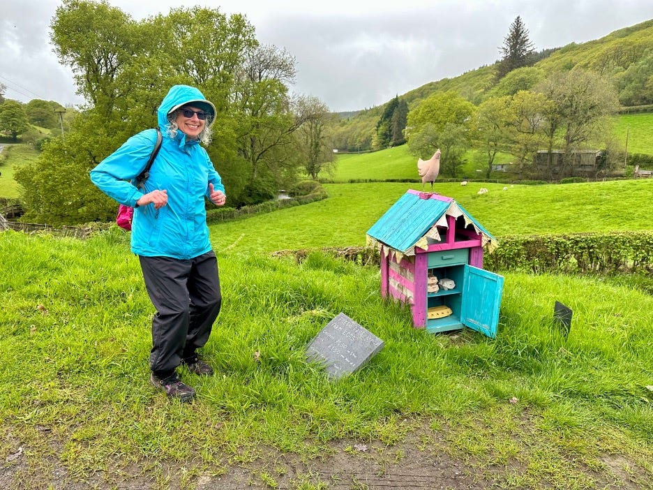
Heading down we ran across an incredibly cute tiny blue and pink house where a farmer was selling farm fresh eggs. It inspired Pam to do the chicken dance next to it in the rain. Fortunately, I was quick with the camera and now I (and you!) have blackmail material to use against her!
Everything was going according to plan when the road that was public access dead ended in a field. We weren’t sure what to do because if we didn’t take that road, we were going to have to go over to a two lane road with fast cars and no sidewalk. We said words like “discretion”, “valor”, and “plead innocent” and just went for it. We were prepared to be taken to jail as scofflaws and hoped that if these stories ended someone would call the UK and ask if we were OK.
We figured we were fine because the path was about 10 feet wide between two fences. We’d walked plenty of those as the farmers leave that space where there’s public access. We still hustled like crazy as we didn’t want to upset any farmer accidentally. We were relieved when we hit the paved road at the end.
After a long, slow, and wet grind, we got to our hotel in Machynlleth, Maenllwyd Guest House, and were relieved to have a “rest day” of only 13.1 miles. Pam the Drying Engineer got to work and almost everything is dried out as I type. We were extremely happy with our decision to cut today short for two reasons. First is that we were both just tired because it’s been a lot of walking. Second, when we looked at the plan for tomorrow, we see that we have the longest day of the trip.
We know we are going to get a good rest because the beds in our room are finally hard. The Welsh seem to love soft beds that to me resemble a trampoline in that every time you move, you bounce a lot. As Pam and I love beds that are as hard as a sheet across a rock, we will be in heaven tonight.
We walked around Machynlleth and did some window shopping. Stopping in a pub to wait for dinner we got into a conversation with a nice couple from Stratford on Avon (literary people with understand). The man is doing Glyndwr’s Way but does a section on Sundays and days free. He’s been hiking like this for years around all the UK. She is the car support and picks him up at the end of the day and watches the dogs. I told them about how people in the US will hike the entire Appalachian a day at a time over years and are given full accolades the same as a through hiker and that he’s just doing the same in England.
For dinner we went to the Wynnstay and their seafood chowder was, oh my god, GLORIOUS! Pam just wanted a taste of mine and when she did, she ran up and ordered her own bowl. As I promised the sheep farmers yesterday that I would eat all the lamb I could, that’s what I did! It was great too.
Thank you so much for reading!
Love Pam being Pam, doing the Chicken Dance!